


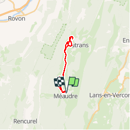
Plaine Méaudre - Autrans

maupassant38
User

Length
17.5 km

Max alt
1070 m

Uphill gradient
316 m
Km-Effort
22 km

Min alt
970 m

Downhill gradient
316 m
Boucle
Yes
Creation date :
2019-02-21 11:57:16.987
Updated on :
2019-02-25 18:24:42.184
2h05
Difficulty : Easy

FREE GPS app for hiking
 SityTrail
IGN / Geographical institutes
SityTrail Plus
The world is yours!
About
Trail Cross-country skiing of 17.5 km to be discovered at Auvergne-Rhône-Alpes, Isère, Autrans-Méaudre en Vercors. This trail is proposed by maupassant38.
Positioning
Country:
France
Region :
Auvergne-Rhône-Alpes
Department/Province :
Isère
Municipality :
Autrans-Méaudre en Vercors
Location:
Unknown
Start:(Dec)
Start:(UTM)
698849 ; 5000463 (31T) N.
Comments